Pierre-Aldric wrote: ↑Wed Dec 04, 2024 10:33 am
Hello, I would like to read a map from geographical point designated in a war diary to a map, Can someone please explain me how can I do that ?
For example:
BELLEBRUNE
FRANCE,
MR 793535 -- This number is the data I would like to know
1/50 000
SHEET N°49
Thanks a lot for your help !
See you soon.
Pierre, I can help you with that…….first you have to have the correct “sheet”, which I suspect you have. What you have is
MR 793535 is called a 6 figure map reference….you can get map reference’s up to 10 figures (artillery usually will use a 10 figure map reference.
So to read a map reference you “go in the door” and “up the stairs”…….what the heck does this mean (you ask)………..well you find the grid square and then you measure ACROSS the bottom line LEFT to RIGHT (in the door) and then you measure BOTTOM to TOP (up the stairs.
So the first numbers you need is the Grid Square Numbers…….in this case you have a 6 Figure Number……..so the first TWO number are the left side line of the grid square, so in this case it is
79………….then we find the bottom line of the grid square which is the NUMBER
53 (you skip over the number 3 and the last number 5 (I’ll explain in a minute) So your grid square in 7953. These are numbers we use to find the bottom/left side point of the GRID SQUARE.
Now each Grid Square in the military is divided into 10 equal parts (both sides) as military grid squares are always in Metric……and a Grid Square is
1000 meters by 1000 meters…………so when you measure inside of the square, you divide it into 10 equal parts. So each or the
10 equal parts are 100 meters each……….SO this means that a 6 figure grid square is accurate to around 100 square meters. The more “grid numbers” (a 8 figure grid square or a 10 meter grid square) the more accurate is your final location. (This is for a 1:250,000 map)
I could NOT find the map your referenced……..but I did find a WW2 map of the area in 1:250,000 so I Used that to plot the location.
So the first map (screen shot) is “larger” so you can see where the location is on a larger map……..I have placed a
RED CIRCLE around the number
79 on the map………….and i have placed a
BLUE CIRCLE around the number
53 on the map. As you can see the number 79 line runs vertically across the map, and 53 line runs horizontally across the map. The map has these numbers on the lines repeated many times, so that you can find the numbers and eventually the grid square quite quickly
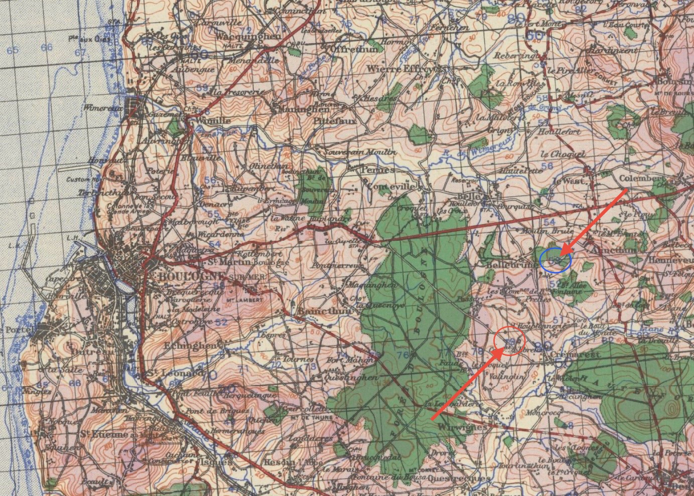
- IMG_0775.jpeg (669.68 KiB) Viewed 30630 times
Then I have “zoomed” into the map (screen shot) to show you a closer few of the map, and again you see the number 79 and the number 53 on this map………and if you use those two numbers you will get the
GRID SQUARE 7935
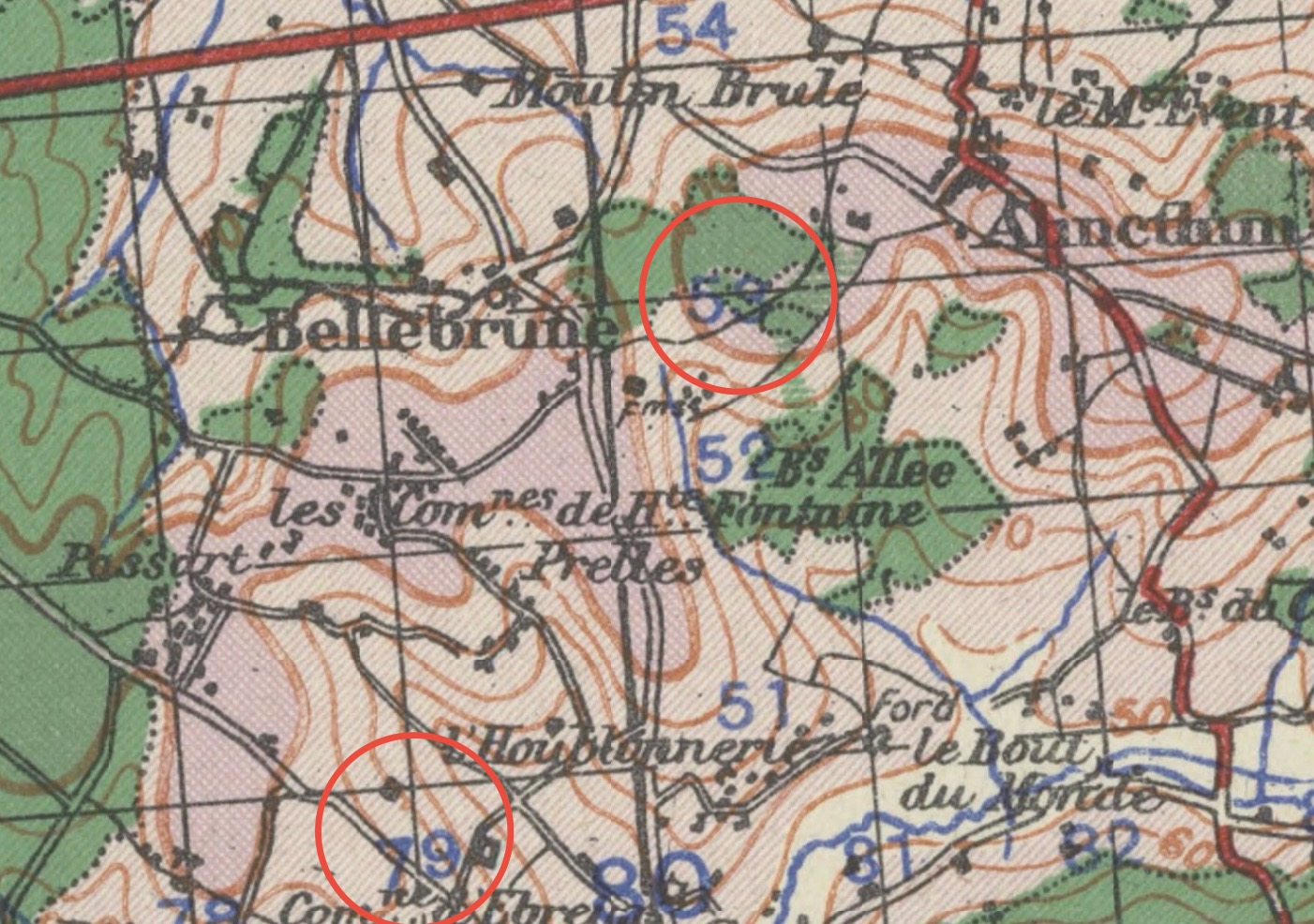
- IMG_0776.jpeg (413.33 KiB) Viewed 30630 times
Finally, I have again “zoomed” into the map (screen shot) and you can see a
RED ARROW that shows you the
BOTTOM LEFT CORNER of Grid Reference
79 53 in World War Two they called them MAP REFERENCES……its exactly the same thing)……….and then you see a
HORIZONTAL BLUE ARROW that shows how you measure ACROSS the square
3 (IN THE DOOR)…………and then a
VERTICAL BLUE ARROW that shows you how to measure UP the square
5 (UP THE STAIRS)………….So as you can see I have broken down the square by 10’s you measure across and find the number 3 (this was the third number on you Map Reference and you measure across
3 marks (IN THE DOOR) and then you go UP THE STAIRS, and you to up the LAST number in your Map Reference which was
5…….. and the location is then shown inside the
RED CIRCLE(I put a red circle around it…….so your with 100 square meters of the location.
NOTE: I straighten the map while using this map segment so that you could see “in the door” and “up the stairs” a little easier. Of course with a real map you would normally “straighten it” on a table or on the ground or hold it in your hand, so it was easier to read and to plot the MR on.
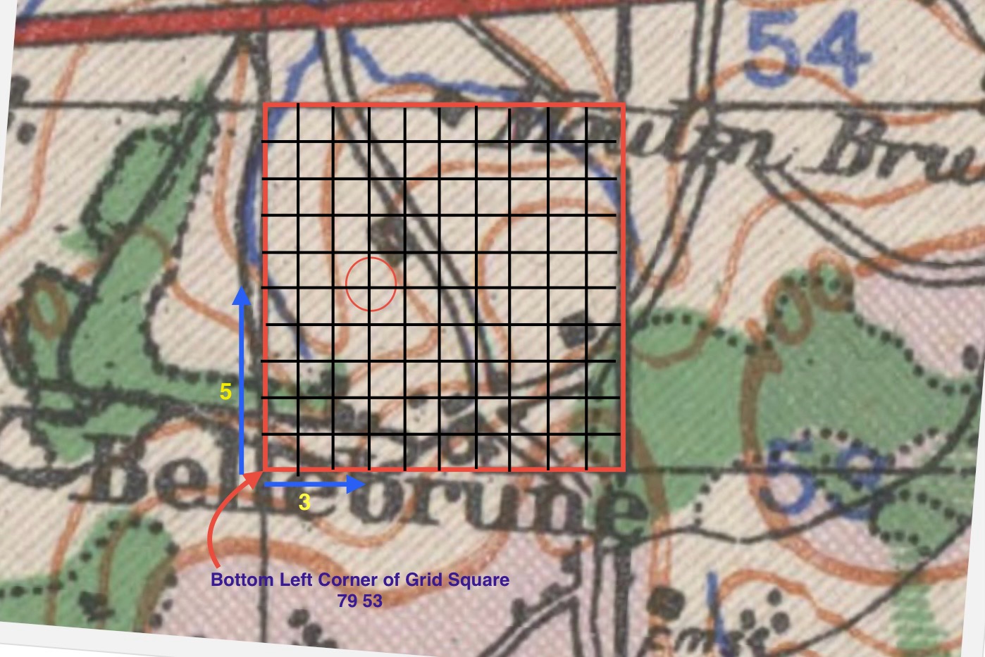
- IMG_0777.jpeg (275.7 KiB) Viewed 30545 times
I know this sounds complicated……..but it is not, you just need a little practice and it clicks in quickly
So a 6 Figure Map (or Grid) Reference is READ
79 3 53 5. The 79 and the 53 represent the GRID (or MAP) SQUARE…….the number 3 represents the “horizontal measurement across the square” and the number 5 represents the “vertical measurement up from the bottom of the square.
So numbers 79 53 is the GRID SQUARE and number 3 & 5 are “measurements within that square. 3 represent 300 meters and 5 represents 500 meters
In the ARMY, ALL soldiers are given a “map reference reader”….(usually a small plastic card) and it has the “break down” of all map sizes scaled on it, so for 1:25,000. 1:50,000. 1:100,000. 1:250,000 so that you can quickly measure the increments on the map
If you DON’T map have this, you take a piece of paper, you mark the measure of the grid square onto one edge and divide into into 10…….and that becomes your “measurement tool”
I do have website that tells you this, and if I find the link I’ll post it.
AND, we STILL USE this system today to manually read maps……..but of course with new technology you can send the map co-ordinates from any electronic device (even your smart watch will give you the map readings)…….in longitude and latitude OR these devices you can key in the MR number of the longitude and latitude (if you know them) and the device will take you exactly to that spot, even if you deviate to go around things (like enemy) or to stay IN COVER while you go to that spot.
Oh, by the way in
World War 1 they used a DIFFERENT map reference system…….it is similar, but has some major differences……so if you need to look at a WW1 Map and Map Reference……..give me a shout and I can explain that too
Hopefully this helps
Cheers